


Boucle Anse Rivière Rouge

Lamartiniere
User GUIDE
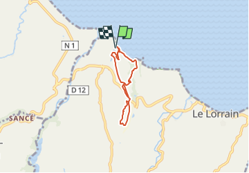

Length
6.1 km

Max alt
154 m

Uphill gradient
174 m
Km-Effort
8.5 km

Min alt
2 m

Downhill gradient
173 m
Boucle
Yes
Creation date :
2025-07-28 14:43:10.403
Updated on :
2025-07-28 14:44:23.575
1h55
Difficulty : Medium

FREE GPS app for hiking
 SityTrail
IGN / Geographical institutes
SityTrail Plus
The world is yours!
About
Trail Walking of 6.1 km to be discovered at Martinique, Unknown, Le Lorrain. This trail is proposed by Lamartiniere.
Positioning
Country:
France
Region :
Martinique
Department/Province :
Unknown
Municipality :
Le Lorrain
Location:
Unknown
Start:(Dec)
Start:(UTM)
706582 ; 1642446 (20P) N.
Comments